Home Other Cruises E-mail

Cruise IntroThe ItineraryBraemarPhotographs

PreviousNext

Braemar in Flåm

Norwegian Flag

Flåm - 27 Aug 2001
My photo album of Flåm Dave's of Flåmsbana

We entered Sognefjord [204 km long], north of Bergen just after 1am when the pilot boarded. Arrived in Flåm at 7.30am, at the southern end of the Aurlandsfjord. What a beautiful place. Tiny little town, spotlessly clean, with a backdrop of steep mountains with numerous waterfalls and around 450 inhabitants. The fjord is beautiful, calm water, one minute sunny the next moody, misty and raining.

Arriving in Flåm
Arriving in Flåm

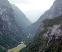
Most of the morning here though it was drizzling. The Port of Flåm was the only place where we were able to dock alongside in the fjords, everywhere else we had to tender.

Flåmsbana
Flåmsbana

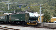
Dave and Howard left us for their tour on the Flåmsbana [Flåm Railway] and would meet the ship in Gudvangen late this afternoon. We could see the train waiting in the centre of Flåm, and when Beverley and I walked off the ship we waved them off, but didn't see where they were sitting.

Top

Propellor belonging to SS Aros

The ship was sunk by the Norwegian Military on 25th April 1940 after German planes had bombed her, amongst other targets in Flåm. The wreck is situated about 1/2 nautical mile from the harbour at a depth of 15m. The Estonian Captain Mihkel Kagi was killed in the bomb attack and buried at Flåm Church.

We walked around the town, went in all the shops, not many, and just took in the scenery. We had to be back on board by 11.15am to sail for Gudvangen. Beverley continued browsing the shops while I wandered up the road with some other passengers, round a bend and to another part of the town where one got a lovely view of Braemar.

Flåm - Looking down Aurlandsfjord

Dave & Howard's trip took them from Flåm in the train from sea level up to a height of 867 metres (2,800 feet) in 50 mins. An ascent of 1 in 18 over a distance of only 20 kilometres (12 miles). The line winds its way through the steep and narrow Flåmsdalen, past Haga Mountain, Flåm Church [1667] and the Rjoande Waterfall [140m vertical drop]. The Berekvam ravine, the Trolla Avalanche, where each winter with normal snowfalls an avalanche thunders down, Kårdal and the Kårdal Waterfall. The Kjos Waterfall, and Bakli tunnel before reaching the Myrdal Plateau where you join the main Oslo/Bergen line to Voss [ski resort] for lunch.

Rjoande Waterfall
Rjoande Waterfall

Top

Voss is one of Western Norway's best agricultural areas. The tour then continues by coach. Past farms and orchards, lakes and rivers, before arriving at the Stalheim Hotel - perched on a cliff with thundering waterfalls diving to the foot of the valley, 550 metres (1,800 feet), below.

Then the descent of Stalheim's Kleivene - possibly Europe's steepest road with a drop of 1 in 5, and 13 hairpin bends. Along the Nærøy River to arrive in Gudvangen, and Braemar.

From the Stalheim Hotel

We departed Flåm at Midday. 19NM to Gudvangen, Norway
My photo album of Flåm Dave's of Flåmsbana

PreviousNext

The Itinerary

The Ship
Braemar Logo

Cruise Intro

Photographs